
 It’s been months since I’ve been out on a trip and my restless feet have been itching to travel. So, when my best friend Winefredo Rodriguez invited me and others to check out Haduan Falls today, I jumped at the chance.
If this is the first time you’ve heard of Haduan Falls, you’re not alone. While the people living near Clark Air Base in Pampanga know of the place, easy access through the creation of a hanging bridge was only recent.
Prior to this, tourists had to travel through a longer route, including having to cross a wide river buried under tons of sand from the Mount Pinatubo eruption.
Table of Contents
The Hesitation
Apart from my family, Win invited another buddy and his family to join us. According to a friend of Win’s wife, the trek would take a scant twenty minutes from the parking area, making it ideal for just about anyone.
[It sounded too good to be true.]

Foot path
Normally, I wouldn’t mind if a climb took twenty minutes or five hours. But this time around, we’ll be accompanied by people who weren’t hikers. So, I was a hesitant to take the word of someone I didn’t know personally. It’s not that I didn’t trust the guy, it’s just that I was unfamiliar with how he’d measure the time and effort needed for the hike.
The problem is that estimating the time and effort to hike up a mountain, or in this case, to a waterfall is subjective. On one hand, people at the peak of their health and who are built like mountain goats will find hikes to be fast and easy. On the other hand, people who aren’t exactly at the peak of health may take it slow and find harder to keep up with others. So, the estimates from both points of view will be different.
[I’m coming from the middle-aged-man-without-exercise point of view, so feel free to extrapolate.]
In an attempt to come up with an estimate, I searched for anything and everything about Haduan Falls. Other than a single write-up, there were just a handful of pictures on the internet because the place is still relatively new to the general public.
From what I could glean, we’d be crossing an ankle-high stream multiple times. And that meant we would need to wear slippers instead of hiking boots or rubber shoes.
[Fabric aqua shoes may not handle the hike on dry ground.]

Karst Wall
Then there was a cliff that needed to be scaled for the last leg of the hike. Based on an initial description, it sounded like it was slippery and a high. Then there were limited pictures of the waterfall which didn’t exactly fill me with awe.
[Making me wonder if it was worth the trip.]
To avoid a worst-case scenario, we rescheduled today’s trip with our non-climbing friends and decided to reconnoiter the place yesterday. If the hike took twenty minutes and didn’t require any athletic prowess, then the entire group would be back as early as next weekend.
So off we went to Clark Air Base on a late Friday morning. And after running a few errands, we finally parked the car on Aeta land and were following our Aeta guide, Akon, to Haduan Falls.
[He said it would take only twenty minutes.]
The Journey
If that was a twenty-minute hike, then our watches must have been defective because it felt like the longest twenty minutes.
The Time
Even after the hike, Akon still stuck to his twenty-minute time. And while he might be able to do it, people who aren’t exactly excellent human specimens should expect to add at least an hour to his estimate.

Stream
I’d say a one-way trip was something like an hour and a half, or about three hours back and forth. It took this long because our party had to take breaks every now and then to catch our breaths. We then spent an additional two hours enjoying the cool, clean water of Haduan Falls in order to wash away our exhaustion.
If you are planning to visit this place, you may want to set aside an entire morning or afternoon for the trip.
The Footwear
If you are the type who is comfortable climbing mountains in slippers, then a pair of flip flops will be fine for you. But if you aren’t a slipper person, or the type who wears a pair that cannot be secured between the toes, then slippers are a bad idea.
Wearing slippers for this hike was a mistake for me because I spent too much energy trying to keep them from coming off as I descended the steep hills. In addition to this, my slippers lacked cushioning which made my knees and feet ache.
[I’m still in pain now.]

Rubber Shoe
Had I known the first two thirds of the trail would be on dry ground, I would have worn hiking boots or rubber shoes. Then for the last third, which required me to cross and wade in the stream, I would have switched to slippers.
If you are wondering whether people can get away with wearing waterproof jelly shoes or solid aqua shoes, yes, it is feasible. But it can be painful when pebbles get lodged inside. One thing to consider is Mount Pinatubo dumped tons of rock and sand on this area during its June 15, 1991 eruption. So stuff entering footwear tend to be jagged instead of smooth.
Should you decide to wear jelly shoes, solid aqua shoes, rubber shoes, or hiking boots, consider wearing socks to help pad your feet from pebbles finding their way in.
Finally, upon reaching the stream, one of the biggest temptations people have is to wade in the water without slippers; please resist this urge. Even our guide told us to keep our footwear on because it was dangerous to go barefoot.
[You can take them off when swimming at the waterfall, though.]
The Terrain
While the terrain wasn’t tough, the steep hills could get slippery because of the dry, loose dirt. Those with poor balance may want to carry a walking stick with them.

Foot Path
One won’t need shoes with spiked soles as flat ones will do. So long as your shoes fit well, you should be fine.
It may be helpful to note that it usually rains in the afternoons, so the terrain can change from being dry and slippery to being wet and slippery. And since the angle of some of the hills can be as high as 40 degrees, you need to constantly look before you step or you’ll find yourself rolling downhill.
[Be careful as it’s more dangerous going down than up.]

Stream
About half of the entire trail is shaded with trees so the burning sun doesn’t feel that bad. Interestingly, the humidity isn’t as high as places like Mount Makiling so people who don’t perspire much may get by with just a small face towel.
Crossing the stream at multiple points meant having to wade in water that can be as shallow as your ankles or as deep as your thighs. Make sure to keep any equipment above water when crossing these portions.
The floor of the stream had a mixture of sand, pebbles, and boulders about half the size of a compact car. But unlike the dry trail, the pebbles here tended to be smooth and not jagged.
Near the end of the waterfall, you will be faced with the option of getting wet or staying dry. Those who can dogpaddle can choose to go take the short route on the right, which is to swim through about six feet of water.

Stream
A slightly longer option is to climb the wall on the left. There are several handholds and footholds to facilitate going up and down. You will need a bit of balance as you ascend and descend this part of the trip, though.
Don’t let the two-story height dissuade you, it only looks daunting from the bottom. Once on top, things aren’t as bad because the path is slightly wider and far enough from the edge. And on the extremely rare chance that you do fall, it will be into six feet of water.
[Well, it’s definitely better than falling on a boulder.]
The Attire
If you are used to walking through high grass that cuts skin, then wearing shorts to keep cool is a good idea. But if you cut easily, then wearing long pants to protect your legs is a better one.

Hat
To keep your upper body cool, a t-shirt will do nicely. But if you are worried about getting your arms cut as you walk by the grass, a light jacket should be enough.
[I’d avoid overly thin materials as they tend to get caught and rip more easily by grass and branches.]
To protect yourself from the sun and occasional hanging branch, a fabric hat can help. Helmets or hardhats aren’t necessary, even for the portion involving the wall as they are bulky and can obstruct one’s vision.
The Sights
The best sight has to be the hanging bridge over the river. When we crossed it yesterday, it was as clean as it could get. The posts supporting the cables had a fresh coat of white paint and were devoid of any graffiti from inconsiderate outsiders. The wooden planks were pristine and didn’t have any names carved in them by unconscionable tourists.

Hanging Bridge
Apart from the paint and pristine wood, the supporting cables still had a thick coat of black sealant to keep the rust at bay. And when we crossed it, there was hardly and vibration or sway.
One consequence of having a lot of shade on a hiking path is that trees obscure the surrounding vistas. However, when the trees did give way to open spaces, some of the sights were quite good.
With nothing blocking the view, the hanging bridge provided an unobstructed look of the river beneath and of the hills on both ends. Those wanting to take pictures may find this to be the best spot for it.

Dragonfly
For people fascinated by insects, they may be happy to learn that the hiking path and stream is teeming with multi-colored Dragonflies and Damselflies. Big and small ones sporting bodies and wings bathed in Red, Green, Blue, and Purple just kept hovering and diving all over the place. And for the first time in my life, I came across several jet black Damselflies resting on rocks in the middle of the water.
[Some of the black ones had neon green or red edged wings.]
Fortunately, there were no leeches so you never have to bother keeping tabs on your skin or, worse, your eyes. Only insects and fish seem to populate the stream.
The Destination
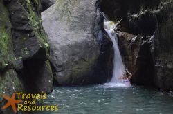
Just as several online pictures depicted, Haduan Falls didn’t look remarkable at first glance. It wasn’t tall, being about two and a half stories. It wasn’t wide, being about a single person in width. And the water wasn’t strong enough to drive anyone downstream. Then there were the surrounding rocks, which were dark and covered in green moss.

Haduan Falls
It was only after getting up close to the waterfall that one begins to appreciate the many little things that make it beautiful.
A pool of water at the base of the Haduan Falls can go as deep as six feet. The water that gently cascaded down was very clear. It was also cool and extremely refreshing. The water didn’t taste like dirt or salt and was as clean as it could get. The entire place was covered in shade so no one had to worry about sunscreen. And since Mount Pinatubo dumped a ton of sand on the area, there was no mud to get between the toes.
[It felt more like a beach than an inland stream.]
If you are the type who doesn’t enjoy hiking, you may still appreciate the waterfall. So while Haduan Falls may not be spectacular from afar, it’s the little things that make the place worth visiting.
The Directions
If you’re traveling on the North Luzon Expressway, or NLEX, head northbound and go out through the Subic-Clark-Tarlac Expressway, or SCTex. After going through the SCTex toll booth you will need to get out at the Clark Exit.

Rest Area
After going through the Clark exit, you will need to turn right at Macarthur Avenue. You will then need to turn right and get on Manuel A. Roxas Highway. At the very end of this highway, turn left on Claro M. Recto Highway. You should pass Fontana Leisure Part on the right.
Keep on going until you reach the very end of this road. You will pass an intersection along the way and find yourself at Gate 14.
You will need to stop here and sign a waiver as you will be leaving private property and entering the living area of the Aetas.
Most likely, an Aeta guide will be on hand at this point and may go on ahead or follow your vehicle in order to direct you to a parking area. If no guide is available, just follow the road to the end and park at the structure without a roof somewhere on the left.
[To be sure, ask for directions along the way.]
Final Thoughts
Don’t get me wrong, the hike was actually quite simple, especially after looking back at the climbs I’ve done over the years. The trail was shaded, the humidity was low, and the distance was not that far. And while healthy people and kids won’t break a sweat, it isn’t for everyone.

Haduan Falls
[People who aren’t in to hiking may not find it to their liking.]
For some middle-aged people who haven’t been using their gym membership, the hike can be a bit exhausting. The good thing is all they may need is to take frequent breaks to recoup some strength. And since the humidity isn’t so bad, recharging shouldn’t take too long.
There was no official entrance fee during our visit yet, but the going rate at the time was PhP 50 per person and payable to the mandatory guide. Since the guides are from the indigenous Aeta people, it would go a long way to give them bit more. PhP 300 should be fine for a party of four, but PhP 500 would be much better if you are happy with the place.
Finally, I didn’t see the need to use anything other than a dSLR telephoto lens with 18mm on it. Much of the view was obscured by trees and the stream leading up to the waterfall was by bordered by cliffs. Even a point and shoot should do alright.
[But then, that’s just me.]
Must Do’s
- Wear hiking boots and shoes for the land hike.
- Switch to slippers when crossing and wading through the stream.
- Wear something light and cool.
- Carry a towel for perspiration and for the swim.
- Consider just taking a do-it-all lens.
Must Don’ts
- Do not litter.
- Do not put graffiti on the bridge or on any of the rocks.
- Do not chew gum and spit it out anywhere in the area.
- Do not take anything back with you other than pictures and memories.
_____________
We would like to thank Mr. and Mrs. Winefredo Rodriguez for arranging the itinerary.

Comments are closed